Exam questions for obtaining aircraft licenses and ratings

PPL(A) -

  1. What is the angle of inclination of the Earth's axis to its orbital plane?

    • The meridian passing through Greenwich is known as?

      • A Rhumb Line is?

        • Variation is the angle between:

          • An Isogonal is a line joining points of:

            • Which points on the Earth's surface determine the Earth's axis?

              • The circumference of the Earth along the Equator is approximately

                • The Earth's diameter, when compared to the Earth' axis, is

                  • Which of the following statements, regarding rotation of the Earth around the Sun, is correct? The Earth :

                    • The Earth's globe rotates :

                      • The orbit of the Earth is:

                        • What is the cause of the seasons?

                          • The shortest distance between two points on the Earth's globe is called:

                            • Great Circle(s) on the Earth's surface is(are):

                              • The equator is the Great Circle which plane:

                                • How many Great Circles (orthodroms) can be determined on the Earth's surface?

                                  • The Great Circle on the Earth's globe is the cross-section of the Earth's surface and the plane passing through

                                    • Which of the following circles on the Earth's globe does not have the center at the Earth's center?

                                      • What is the characteristic of the Rhumb Line?

                                        • Which circles, forming the graticule, are at the same time Great Circles and Rhumb Lines?

                                          • The Sun travels across the sky an arc of 5° in

                                            • What time is needed for the Sun's azimuth to change by 27 arc degrees?

                                              • The Co-ordinated Universal Time (UTC) is

                                                • 13:00 accordingly to the MidEuropean Summer Time is

                                                  • An aircraft over Belgrade is headed exactly to the south. It is 1200 UTC. What is theRelative bearing of the Sun?

                                                    • The geographic latitude is the distance of a point on the Earth's surface from the

                                                      • What is the latitude of a point on the Equator?

                                                        • Longitude change between point A (04° 14' 28" E) an B (02° 30' 30" E) on the Earth's globe is

                                                          • What is the difference between the latitude of the point A and the point B, which are located on following parallels of latitude: A: 15° 54' 30" N B: 10° 33' 30" S

                                                            • Determine the latitude of the point B, located 240 NM north of the point A with the latitude 62° 33' 00" N.

                                                              • The distance between the parallel of latitude 10°N and the parallel of latitude 11°N, measured along the meridian, is

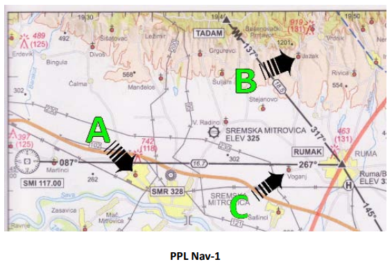
                                                                • The geographic coordinates of the point A are(see Figure PPL Nav-1)

                                                                  • The geographic coordinates of the point B are(see Figure PPL Nav-1)

                                                                    • The geographic coordinates of the point C are(see Figure PPL Nav-1)

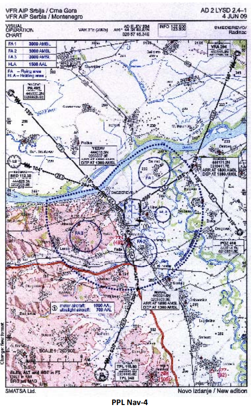
                                                                      • Which point has the geographical coordinates N 44° 33, 2' and E 20° 59, 0'? (see Figure PPL Nav-4)

                                                                        • The geographic coordinates point DUBRA are (see Figure PPL Nav-4)

                                                                          • 11 km north of the geographic coordinates N 44 ° 41.3 'E and 21 ° 04.1' is the place? (see Figure PPL Nav-4)

                                                                            • The distance of 1 NM is equivalent to

                                                                              • The distance of 1 NM equals to

                                                                                • The formula for a quick calculation from kilometres to nautical miles is:

                                                                                  • Approximately how many kilometres are in 70 nautical miles?

                                                                                    • The distance of 1 statute mile is equal to

                                                                                      • How many kilometres are in 50 SM (statute miles)?

                                                                                        • Where on the chart can the distance between the two points be determined, which has been callipered by a pair of compasses or marked on the edge of a piece of paper?

                                                                                          • On a chart, 6 cm represents the distance 15 km. What is the scale of the chart?

                                                                                            • The scale of the chart is 1:500 000. How many centimetres represents the distance 105km?

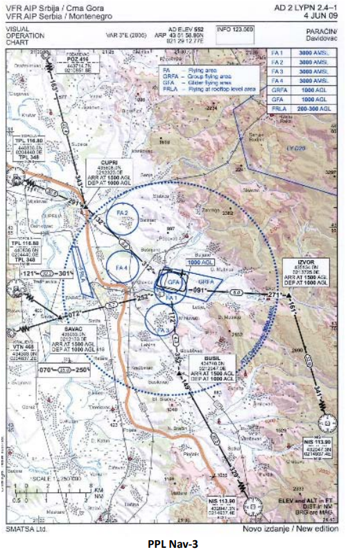
                                                                                              • The scale of the chart is? (see Figure PPL Nav-3)

                                                                                                • The scale of the chart is 1:300 000. How many centimetres represents the distance 210km?

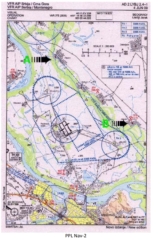
                                                                                                  • The attached map distance between points A and B is 9 cm. how many kilometers is it? (see Figure PPL Nav-2)

                                                                                                    • The attached map distance between points A and B is 9 cm. how many Nm is it? (see Figure PPL Nav-2)

                                                                                                      • The distance between the points ALFA and BRAVO is 107 NM. If an aircraft covers first 16 NM in 10 minutes, what time does it take to travel the entire route ALFA-BRAVO with the same groundspeed?

                                                                                                        • How far will an aircraft travel with 32 gal of usable fuel with fuel consumption 7,1 gal/h at the groundspeed 108 kts? (Allow 1-hour final reserve fuel)

                                                                                                          • How far will an aircraft travel with 27 gal of usable fuel with fuel consumption 6,8 gal/h at the groundspeed 93 kts? (Allow 6-gallons final reserve fuel)

                                                                                                            • How many gallons of usable fuel should be on board of an aircraft for a distance flight of 300 NM at the groundspeed 120 kts and average fuel consumption 7,3 gal/h? (Allow 1-hour fuel reserve).

                                                                                                              • A distance in meters could be converted to feet using the formula:

                                                                                                                • An altitude 1,500 meters is approximately

                                                                                                                  • On a chart we read the obstacle altitude 275 meters. Regarding the rule of height clearance 1,000 feet over obstacles, what is the lowest altitude for overflying the obstacle?

                                                                                                                    • Altitude 6,000 ft is approximately

                                                                                                                      • Approximately what QNH pressure corresponds to the QFE pressure 1000 hPa on an airfield with the elevation 200 meters?

                                                                                                                        • If a pilot changes the altimeter setting from 996 hPa to 1033 hPa, the altitude indication will

                                                                                                                          • When set to 1008 hPa, an aircraft's altimeter indicates 1,600 ft. What would be the indication if setting is changed to 1009 hPa?

                                                                                                                            • If a pilot changes the altimeter setting from 1010 hPa to 1000 hPa, what is the approximate change in indication?

                                                                                                                              • What does a measuring unit knot used in aviation mean?

                                                                                                                                • The wind velocity of 10 m/sec approximately equals to

                                                                                                                                  • Wind velocity 5 kts is approximately

                                                                                                                                    • A velocity 120 km/h, expressed in knots, is

                                                                                                                                      • If a vertical speed indicator of a towing airplane shows 500 ft/min, the approximately aerotow's rateof-climb in meters-per-second is

                                                                                                                                        • What is the ground speed (GS) of an aircraft, covering in 40 minutes the distance, that represents 10.8 cm on an 1:500 000 chart?

                                                                                                                                          • An aircraft would cover a 120 km-distance in no wind condition in 2 hours and 40 minutes, however in actual meteo conditions the flight lasted 3 hours and 5 minutes. What was the longitudinal wind component on route

                                                                                                                                            • The distance of the route from the point X to the point Y via the control point Z is 84 km. If an aircraft covers the first segment X-Z (35 km) in 50 minutes, what will be the total time of flight between the points X and Y

                                                                                                                                              • How far will an aircraft travel in 2-1/2 minutes with a groundspeed of 98 knots?

                                                                                                                                                • 100 kg is how many pounds?

                                                                                                                                                  • 90 pounds is how many kilograms?

                                                                                                                                                    • 25 US gallons is how many liters?

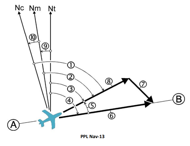
                                                                                                                                                      • Which mark on the wind triangle represents a true course? (see Figure PPL Nav-13)

                                                                                                                                                        • Which mark on the wind triangle represents a true heading?

                                                                                                                                                          • Which mark on the wind triangle represents a magnetic heading? (see Figure PPL Nav-13)

                                                                                                                                                            • Which mark on the wind triangle sketch denotes a compass heading? (see Figure PPL Nav-13)

                                                                                                                                                              • Which mark on the wind triangle represents a wind correction angle? (see Figure PPL Nav-13)

                                                                                                                                                                • Which mark on the wind triangle represents a magnetic variation? (see Figure PPL Nav-13)

                                                                                                                                                                  • Which mark on the wind triangle represents a compass deviation? (see Figure PPL Nav-13)

                                                                                                                                                                    • Which mark on the wind triangle represents an aircraft's true airspeed (TAS)? (see Figure PPL Nav-13)

                                                                                                                                                                      • Which mark on the wind triangle represents an aircraft's ground speed (GS)? (see Figure PPL Nav-13)

                                                                                                                                                                        • Which mark on the wind triangle represents a wind vector? (see Figure PPL Nav-13)

                                                                                                                                                                          • What is the meaning of the term 'drift angle' in navigation?

                                                                                                                                                                            • A Wind Correction Angle is the angle difference between

                                                                                                                                                                              • Which azimuth corresponds to the general direction WNW?

                                                                                                                                                                                • Which parameter is included in the reckoning of a magnetic course?

                                                                                                                                                                                  • The angle between a direction toward geographic north and a direction toward magnetic north is called

                                                                                                                                                                                    • The magnetic variation value of a given point on the Earth's surface can be obtained by

                                                                                                                                                                                      • Lines on geographical charts joining points of equal magnetic variation, are called

                                                                                                                                                                                        • Lines on geographical charts joining points of a zero magnetic variation, are called

                                                                                                                                                                                          • What is the magnetic variation of the area? (see Figure PPL Nav-3)

                                                                                                                                                                                            • When calculating magnetic direction from a given true direction, westerly variation should be

                                                                                                                                                                                              • Magnetic course is calculated using the equation

                                                                                                                                                                                                • Magnetic heading is

                                                                                                                                                                                                  • Is it possible for a desired true track, true heading and actual true track to have the same value?

                                                                                                                                                                                                    • Which element of the wind triangle has a null value if a magnetic heading equals compass heading?

                                                                                                                                                                                                      • The true heading for a flight between two points of a route is 270° and the wind correction angle is -10°. What will be the true heading for a return flight between the same points?

                                                                                                                                                                                                        • Which statement is true about homing when using ADF?

                                                                                                                                                                                                          • To use an VHF/DF facilities for assistance in location an aircraft's position, the aircraft must have a

                                                                                                                                                                                                            • An NDB normally transmits on which frequency band?

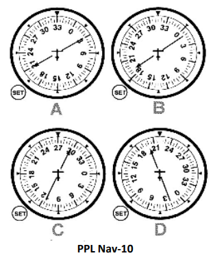
                                                                                                                                                                                                              • As shown by ADF A, the relative bearing TO the station is (see Figure PPL Nav-10)

                                                                                                                                                                                                                • As shown by ADF B, the relative bearing TO the station is (see Figure PPL Nav-10)

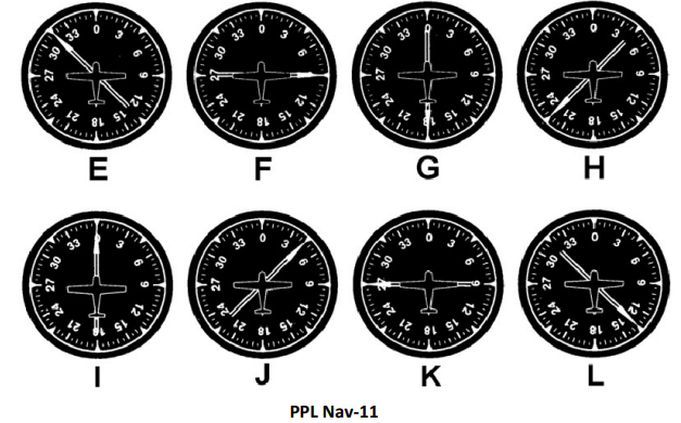
                                                                                                                                                                                                                  • As shown by ADF D, the relative bearing TO the station is (see Figure PPL Nav-11)

                                                                                                                                                                                                                    • As shown by ADF E, the relative bearing TO the station is (see Figure PPL Nav-11)

                                                                                                                                                                                                                      • As shown by ADF F, the relative bearing TO the station is (see Figure PPL Nav-11)

                                                                                                                                                                                                                        • As shown by ADF G, the relative bearing TO the station is (see Figure PPL Nav-11)

                                                                                                                                                                                                                          • As shown by ADF A, the magnetic bearing TO the station is (see Figure PPL Nav-10)

                                                                                                                                                                                                                            • If receiving ADF indication B, what magnetic heading should the aircraft be turned to fly directly to the NDB station? (see Figure PPL Nav-10)

                                                                                                                                                                                                                              • If receiving ADF indication B, what approximate magnetic heading should the aircraft be turned to intercept the 180° bearing TO the station? (see Figure PPL Nav-10)

                                                                                                                                                                                                                                • If an ADF indicator in the cockpit corresponds to the figure C, the magnetic bearing FROM the station is (see Figure PPL Nav-10)

                                                                                                                                                                                                                                  • Which of the figures corresponds to an ADF indicator of an aircraft, flying TO the station with a right crosswind? (see Figure PPL Nav-10)

                                                                                                                                                                                                                                    • What is the magnetic bearing FROM the station of an aircraft with an ADF indication, depicted in figure A? (see Figure PPL Nav-10)

                                                                                                                                                                                                                                      • On a magnetic heading of 320° and with an ADF indication as figure H, the magnetic bearing TO the station is (see Figure PPL Nav-11)

                                                                                                                                                                                                                                        • On a magnetic heading of 035° and with an ADF indication as figure I, the magnetic bearing TO the station is (see Figure PPL Nav-11)

                                                                                                                                                                                                                                          • On a magnetic heading of 120° and with an ADF indication as figure J, the magnetic bearing TO the station is (see Figure PPL Nav-11)

                                                                                                                                                                                                                                            • If the magnetic bearing of an aircraft TO the station is 240°, what is the magnetic heading if the ADF indicator corresponds to the figure J? (see Figure PPL Nav-11)

                                                                                                                                                                                                                                              • If the magnetic bearing of an aircraft TO the station is 030°, what is the magnetic heading if the ADF indicator corresponds to the figure K? (see Figure PPL Nav-11)

                                                                                                                                                                                                                                                • If the magnetic bearing of an aircraft TO the station is 135°, what is the magnetic heading if the ADF indicator corresponds to the figure L? (see Figure PPL Nav-11)

                                                                                                                                                                                                                                                  • Choose the correct sequence of procedures in the cockpit for flying inbound to the VOR station. a) Rotate the OBS selector knob to center the CDI needle with TO indication. b) Check the identification signal. c) Check for proper frequency selected. d) Turn the aircraft into the heading, equal to the radial selected on the OBS.

                                                                                                                                                                                                                                                    • VOR radials are

                                                                                                                                                                                                                                                      • An aircraft has a DME reading 120 miles from a VOR station and a CDI indication is one-fifth of a full deflection to one side. Approximately how many miles off the course centerline is the aircraft?

                                                                                                                                                                                                                                                        • When using a VOR for navigation, station passage is indicated

                                                                                                                                                                                                                                                          • Which situation would result in reverse sensing of a VOR receiver?

                                                                                                                                                                                                                                                            • To track outbound on the 180 radial of a VOR station, the recommended procedure is to set the OBS to

                                                                                                                                                                                                                                                              • To track inbound on the 215 radial of a VOR station, the recommended procedure is to set the OBS to

                                                                                                                                                                                                                                                                • With a VOR/ILS receiver set to a VOR frequency, how many degrees does full deflection of a CDI to one side represent?

                                                                                                                                                                                                                                                                  • An aircraft 60 miles from a VOR station has a CDI indication one-fifth deflection, this represents a course centerline deviation of approximately

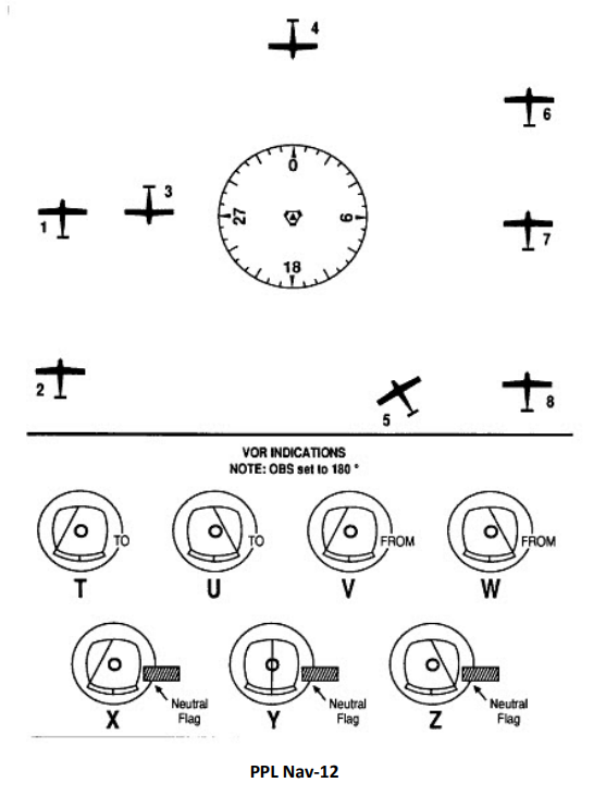
                                                                                                                                                                                                                                                                    • Which airplane(s) correspond(s) to the VOR indicator V? (see Figure PPL Nav-12)

                                                                                                                                                                                                                                                                      • Which airplane(s) correspond(s) to the VOR indicator X? (see Figure PPL Nav-12)

                                                                                                                                                                                                                                                                        • Which airplane(s) correspond(s) to the VOR indicator U? (see Figure PPL Nav-12)

                                                                                                                                                                                                                                                                          • Which presentation of a VOR indicator corresponds to airplanes 8? (see Figure PPL Nav-12)

                                                                                                                                                                                                                                                                            • Which presentation of a VOR indicator corresponds to airplanes 5 and 7? (see Figure PPL Nav-12)

                                                                                                                                                                                                                                                                              • Which of the following statements, regarding a DME operation, is correct?

                                                                                                                                                                                                                                                                                • Which distance is displayed by a DME indicator?

                                                                                                                                                                                                                                                                                  • What is the DME reading if an aircraft is directly over a VOR/DME station at the altitude of 6,000 ft AGL?

                                                                                                                                                                                                                                                                                    • The slant-range error of a DME is greatest at

                                                                                                                                                                                                                                                                                      • Directions of airways on the Jeppesen radio navigational chart in Appendix are (see Figure PPL Nav3)

                                                                                                                                                                                                                                                                                        • Waypoints data in a GPS database (with the exception of users waypoints) could be updated by

                                                                                                                                                                                                                                                                                          • A CDI deviation needle on the GPS electronic screen in the cockpit shows a deviation from the desired track in

                                                                                                                                                                                                                                                                                            • Similarly to a VOR, the accuracy of a GPS in great extend depends on the distance to the point selected.

                                                                                                                                                                                                                                                                                              • A GPS leads an aircraft on route along

                                                                                                                                                                                                                                                                                                • Which directions are normally selected when setting a GPS?

                                                                                                                                                                                                                                                                                                  • A GPS signal receptions in great extend depends on the aircraft's altitude. This statement is

                                                                                                                                                                                                                                                                                                    • When working with a GPS one must know that

                                                                                                                                                                                                                                                                                                      • Which map datum should be selected at GPS initialization?

                                                                                                                                                                                                                                                                                                        • Which velocity is measured in principle by every GPS instrument?

                                                                                                                                                                                                                                                                                                          • A GPS signal may be interrupted when transmitting on VHF frequencies

                                                                                                                                                                                                                                                                                                            • In a RNAV mode, the lateral deflection of the CDI indicates

                                                                                                                                                                                                                                                                                                              • navigation-1.png
                                                                                                                                                                                                                                                                                                              • navigation-2.png
                                                                                                                                                                                                                                                                                                              • navigation-3.png
                                                                                                                                                                                                                                                                                                              • navigation-4.png
                                                                                                                                                                                                                                                                                                              • navigation-5.png
                                                                                                                                                                                                                                                                                                              • navigation-6.png
                                                                                                                                                                                                                                                                                                              • navigation-7.png
                                                                                                                                                                                                                                                                                                              • navigation-8.png